Since our successful, even transformative paddle camping trip to Indian Arm, Johnny and I have been eager to go again. We narrowed our destinations down to two options: Pitt Lake and Sechelt Inlet. After doing ample research on both, and watching the forecasts for weather and air quality like hawks, we finally settled on Sechelt Inlet for our second SUP camping trip. (The Fraser Valley was more smokey and the temperature at Pitt Lake was forecasted to reach an insane 40 degrees celsius.)
Sechelt Inlet in some ways are quite similar to Indian Arm: it’s a long and narrow inlet that’s very well sheltered from the ocean; the paddle route is well documented (this is the best kayak camping guide I found), and there are multiple free, first-come-first-served BC Parks marine accessible campsites; the views are top-notch, and marine wildlife is abundant. Both have predictable, strong southerly thermal winds in a summer afternoon.
There are also some important differences. As it’s a ferry ride away from Vancouver, it takes considerable time and effort to get to and fro. Ferry fare aside, you have to line up for the ferry 30 to 60 minutes before the sailing departure (>60 minutes is recommended if you don’t have a reservation). That and the 40 minute ferry ride adds approximately 4 hours of commute time to the trip. There’s also the very real risk and associated anxiety of missing a sailing. The ferry barrier reduces the traffic on the water significantly though, so it can also be seen as a positive.
Also, parking in Tuwanek, the usual launch point into Sechelt Inlet, is somewhat tenuous; the official website for Pedals and Paddles, the go-to paddle rental and guiding service for the area, doesn’t mention parking as a service they provide, and there is a “No Overnight Parking” sign at the Lamb Bay parking lot. The streets in Tuwanek are quite narrow, making street parking seem intrusive.
With that said, the allure of paddling Sechelt Inlet was undeniable. We caught a glimpse of it when we camped at Porpoise Bay earlier in the season, and we vowed to come back.
Our trip didn’t get to a perfect start. I underestimated the time it took for me to go pick Johnny up, and we hit traffic on Highway One. We got to the Horseshoe Bay terminal after 7am, so we missed the first sailing of the day at 7:30am. The next sailing? 9:50am. So right off the bat, we were 2.5 hours behind schedule. Johnny was a good sport and we took a stroll through Horseshoe Bay village while we waited.


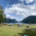
The drive to Tuwanek was uneventful. We followed the sign for “water access” and found the Lamb Bay parking lot quite easily. However, we were surprised by a “no overnight parking” sign in the parking lot, so I called Pedals and Paddles, the local kayak rental shop. They were gracious enough to offer us parking at their lot for $5 per night, plus $10 for launching our paddleboards, even though we are not renting from them. They also informed us that the residents put up the no parking sign because someone was running an Airbnb and using the parking lot as their own, and that visiting paddlers have not had an issue parking here. Of course this is informational only, and parking here would be at our – and yours if you park here too – own risk.
I wonder if Sechelt could work with BC Parks to open some overnight parking spots at the huge lots at Porpoise Bay…

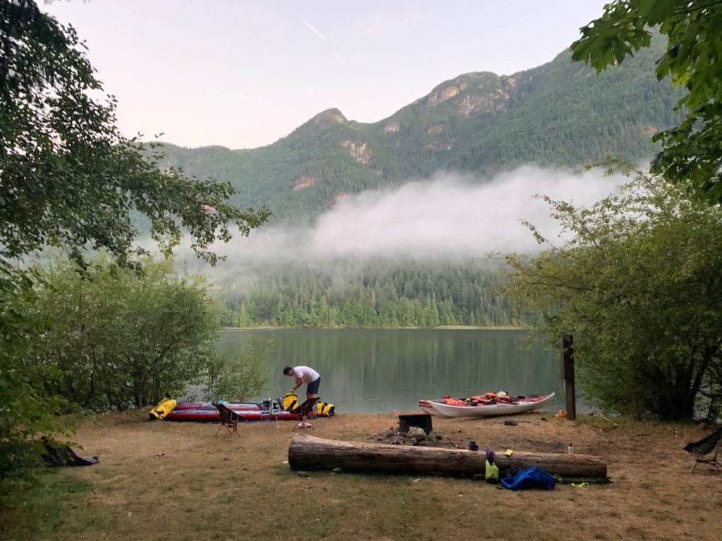
Since we were already parked and quite behind on our schedule, we stayed at Lamb Bay to launch. There is a portable toilet at Lamb Bay, and launching from the protected sandy beach was very easy.


We were quite aware of the strong southerly wind and we hoped to launch around 9:30am to avoid the worst of it. Instead we launched at 12:30pm, a solid 3 hours behind schedule and right into some pretty dramatic winds and waves.

Thankfully we were down-winding the whole way. The Windy app called for a 15km/h westerly wind in the region, but it’s not even a factor in the inlet. The mountains blocked the winds from the sides, and the overwhelming southerly wind dominated the whole inlet.


The geography of Sechelt Inlet is quite interesting. It’s roughly shaped like the letter “F”, with 3 interconnecting inlets: the vertical Sechelt Inlet, and the horizontal Narrows Inlet near the north and Salmon Inlet near the middle. The city of Sechelt is at the bottom.
Within 2 hours, we arrived at the famously windy Salmon Inlet. I was expecting a messy mixture of winds from the east and south, but it was just more of the southerly wind. The wind was kicking up 1 foot waves, enough to plunge the front half of my touring board in the water.

After a good 20-30 minute battle, we arrived at Kunechin Point. The wind and waves calmed right down in a protected nook, so we took a breather here. We chatted with a nice couple who were kayak camping here, and the girl recognized our boards from my previous blog post on Indian Arm. Thus I achieved my first blog reader connection on the water! They kindly recommended checking out the meteor shower and bioluminescence, both of which should be on full display.
Kunechin Point is one of the 9 provincial campsites in the inlet, but since it’s only 3pm and 12km from Tuwanek, we made the decision to push forward to Tzoonie Narrows. It’s a commitment though, since there were no more campsites in the 12-km stretch between Kunechin and Tzoonie.


After 2 hours, we arrived at the mouth of Narrows Inlet. The view down Narrows Inlet felt somewhat anti-climatic, with Salmon Inlet having the better view. We were also quite tired when we got here, so that may have affected our appreciation of the scenery.

It took another hour of paddling in Narrows Inlet to finally arrive at the Tzoonie Narrows campsite. We were both running on fumes at this point. After 25 km of consecutive paddling, we have set a new single-day record and found our current paddling limit.

Another group of kayak campers were at the campsite already. With no other obvious place for easy landing, I approached the park sign and asked the campers: “Hello! Is this where people land?”
A man in the group reminded me of Jim Hopper from Stranger Things. Jim and his friends were very friendly.
“Hello, yes! Are you looking for Tzoonie Narrows?”
“No, I’m looking for Vancouver,” I joked.
“Haha, it’s a couple of days that way!” he pointed behind me. We shared a laugh. Jim let us know the lay of the land a bit. The campsites at Tzoonie Narrows were somewhat disappointing. Most of them were tucked in the woods away from the ocean, and connected by a narrow trail that lead quite far away from the beach. A fallen tree even blocks this trail so we didn’t explore further.


Thankfully, Jim and his friends were kind enough to move their chairs so we could have a prime spot just steps away from the water’s edge to set up camp.


We skipped the rainfly again and headed to bed around 9 pm. We were both quite exhausted, having waken up early for the ferry we missed. Jim and his company actually had the exact same thing happen to them: they got to the ferry terminal at 6:50 am, and still missed the 7:30 am sailing by 20 cars.

Around 1 am in the morning, I got to a lighter sleep stage and decided to open my eyes and put on my glasses to check the sky. I let out an audible “whoa!” that woke Johnny up: the sky was full of stars!
The conditions were ideal. The night was cloudless and the moon was a very thin crescent that has already disappeared behind the mountains, so there was not a flicker of light other than star light when we turned off our headlamps.

Without the rainfly, we could stargaze without getting out of our sleeping bags, but we didn’t see many meteors. We got out of our tent anyway to check on the bioluminescence.
I stirred the water with my hand and saw sparkles. I splashed around with my paddle, more sparkles. I decided to take the paddleboard for a spin, and had the most surreal experience of paddling under the milky way with meteor shower above, and underwater fireworks below with every stroke.
We lingered on the water in near complete darkness (we found out that we could still see shapes by nothing but starlight) for a few minutes that felt out of this world, but we had to head back to bed because we planned to get up again at 5am to get an early start and avoid the afternoon winds.


After breakfast, we took down our camp and launched at 6:30am.

At the mouth of the Narrows Inlet, there was a small settlement with houses, roads, cars, and docks. It even had a cellphone tower on the top of the hill, so the cellphone reception here was actually fantastic. Who would have thought you could get LTE coverage on a remote paddle camping trip.

Our first objective was crossing Salmon Inlet before the wind started. It was challenging enough down-winding across Salmon Inlet, and if we had to go up-wind in that condition? We would likely have to give up and camp an extra night at Kunechin.
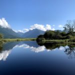
We arrived at Salmon Inlet around 9am, and it was completely different from the day before. The water was extremely calm, with all but a ripple from a gentle breeze.


We stayed on the east shore to avoid the sun as much as possible, but the sun still poked out from behind the mountains eventually.


We arrived back at Lamb Bay around noon, just as the winds started to pick up. We were very glad to beat the wind. After paddling nearly 50km within a 24 hour span, we didn’t have much left in the tank to battle a strong head wind.

After the trip we had a debrief. Going all the way to Tzoonie Narrows from Tuwanek in one day on a SUP was challenging and boundary testing for us. The stars and bioluminescence at night was unbelievable. But the views at Tzoonie Narrows and Narrows Inlet were not the most spectacular in Sechelt Inlet. Kunechin Point probably had better views, looking up and down Sechelt Inlet as well as Salmon Inlet. If we were to visit Sechelt Inlet to paddle camp again, we would probably stay a night a Kunechin and check out Salmon Inlet on the second day before heading home.


Discover more from Outdoor Family
Subscribe to get the latest posts sent to your email.
Pingback: Camping at Ruckle Provincial Park on Salt Spring Island – Outdoor Family
Pingback: Stearman to Dundarave Paddle – a humbling experience – Outdoor Family
Pingback: Sunshine Coast: Sechelt – Outdoor Family
Pingback: Paddle Camping at Moyer Creek Marine Campsite in Golden Ears Provincial Park - Outdoor Family
Hi, I am planning on doing a 3-4 day multiday paddle the week of Oct 9, and debating between Sechelt Inlet and Indian Arm. I see you’ve done both! Consider what each offer and the time of year, which would you recommend more?
Hi Alex, the two locations are similar in many ways. Both are narrow, north-south oriented fjords. Indian Arm is considerably busier with human activity. Sechelt has more campgrounds and places to explore than Indian Arm, and you can camp at a different campsite every day for the 3-4 day trip. If you spend 4 days in Indian Arm you will probably stay in the same location and chill for 2 of those days.
If the forecast is pretty comparable, it really comes down to what kind of trip you wish to have. Exploring a new place every day vs. relaxing next to a waterfall for a few days.